
Lost city founded by Alexander the Great has finally been located and scientifically confirmed after decades of uncertainty. Archaeologists now say that the long-missing city established by Alexander during his return from the Indus Valley around 324 BC has been definitively identified in southern Iraq, close to today’s Iranian border.
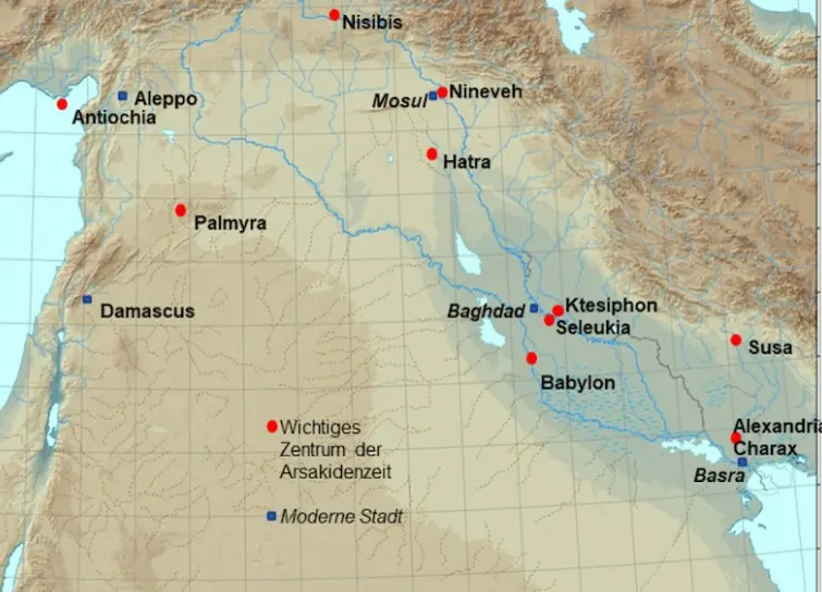
The discovery confirms that the massive ruins known locally as Jebel Khayyaber are in fact the remains of Alexandria on the Tigris, later known as Charax Spasinou—one of the most important trade cities of the ancient world.
A City Hidden in Plain Sight for Centuries
Stretching across the flat alluvial plains of southern Iraq, the site is marked by enormous defensive walls that can reach up to eight meters in height and extend for several kilometers. For centuries, these structures were visible only from the air, yet their true identity remained unknown.
Political instability, armed conflict, and long-standing academic biases kept the region outside the focus of large-scale archaeological research. As a result, the city gradually disappeared from collective memory.
From Ancient Texts to Modern Confirmation
The first serious clue emerged in the 1960s, when researcher John Hansman studied Royal Air Force aerial photographs and linked the visible walls to descriptions written by the Roman author Pliny the Elder in the 1st century AD. However, the theory could not be verified on the ground for decades.
That changed in the early 21st century, when an international research team led by Professor Stefan Hauser of the University of Konstanz began systematic investigations. Their work ultimately confirmed that the site was indeed the lost city founded by Alexander the Great.
Dangerous Fieldwork in a Conflict Zone
Access to the site only became possible again in 2014, after foreign research teams were allowed to return to the region. Even then, security risks were severe. Archaeologists conducted surveys under armed protection, often limited to surface studies due to ongoing instability.
Using drones, researchers captured thousands of aerial images, later processed through photogrammetry to create detailed topographic models. The results were clear and undeniable: the city was enormous, rivaling Alexandria in Egypt in both scale and planning.
A Metropolis Designed for Global Trade
The lost city founded by Alexander the Great was strategically positioned at the meeting point of major river and sea routes. Located near the junction of the Tigris River and the Karun River, and once only a few kilometers from the Persian Gulf, the city served as a vital transfer hub.
For more than 550 years, it functioned as a key node connecting maritime trade routes from the Indian Ocean with inland river and land routes across Mesopotamia. Spices, textiles, metals, and other valuable goods passed through the city on their way to major capitals such as Seleucia and Ctesiphon.
Advanced Technology Reveals the City Plan
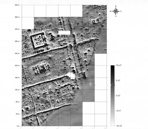
Due to safety concerns, archaeologists relied heavily on non-invasive geophysical techniques. Using cesium magnetometers, researchers detected underground anomalies caused by walls, streets, kilns, and buildings without excavation.
The magnetic data revealed a remarkably clear urban grid system, including some of the largest residential blocks known from the ancient world. Streets remained perfectly aligned even two kilometers south of the northern city wall, showing an extraordinary level of planning precision.
Later analysis identified up to four different orientation phases, indicating long-term urban development rather than a static design.
Temples, Workshops, Palaces, and Irrigation Systems
The surveys revealed specialized districts within the city. Large residential areas were interrupted by monumental temple complexes. Near the river port and canal network, clusters of workshops and furnaces indicated intensive industrial activity.
In another area, researchers identified an isolated palace-like structure, possibly surrounded by gardens or even used for indoor agriculture. Satellite imagery further north revealed remains of a vast irrigation system likely used to support agriculture for the city’s population.
Rise, Prosperity, and Environmental Collapse
The city reached its peak between 300 BC and AD 300, during a period of intense trade with India, Afghanistan, and China. Over time, however, environmental changes sealed its fate.
Sediment buildup gradually pushed the Persian Gulf coastline further south, while the Tigris River slowly shifted its course westward. As the river moved away, the city lost its direct water access—an existential blow for a trade-based settlement.
Geological studies show that the city was largely abandoned by the 3rd century AD. Ancient sources suggest that by then, the coastline had retreated nearly 180 kilometers.
A Legacy Continued by Modern Basra
After losing its role as a regional capital and trade hub, the city was eventually deserted. Its economic and geographic legacy, however, lived on. Modern Basra inherited its function as a gateway between the Gulf and Mesopotamia.
Despite the progress made so far, many questions remain unanswered. Future excavations—pending funding and improved security—could reveal daily life, social organization, and cultural practices in this extraordinary ancient metropolis.
The confirmation of the lost city founded by Alexander the Great marks one of the most significant archaeological breakthroughs in recent decades, reshaping our understanding of ancient trade, urban planning, and imperial ambition.
source: Universität Konstanz. January 28, 2026.
0 Comments